Three months ago, Billo and I sat drinking a beer overlooking the Mediterranean in Beirut. Yesterday we sat drinking fermented grapes (it would be wrong to call it wine) overlooking Nanga Parbat - one of the world's highest mountains.
It has been an epic journey: We have travelled by land as far away from the sea as it is possible to go. We have visited ten countries for the first time (eleven if you include our brief illicit visit to Afghanistan) and met all the Stans except Kazakhstan. And that wasn't for the lack of trying: Billo even bought a visa but we simply did not have the time.
In three months, there is no doubt that we have packed it in. We have visited the oldest city in the world, the largest bazaar and surely made a dent in UNESCO's list of World Heritage sites. We have seen a bewildering array of mosques, minarets and blue tiled domes. Our journey has taken us across sweltering deserts, up high altitude snowy passes and across some of the most hair-raising roads on earth. On foot, We have trekked in the Pamirs, the Karakorum and the Himalaya, taking in a 5000m peak and the base camp of one of the world's few 8000m+ peaks.
We have stayed in a 19th Century traditional Uzbek house, a Kyrgyz yurt, a Tajik mud hut, a cave, a tent, a number of Soviet monstrosities and on two occasions - unexpectedly - in hotels that seemed to be making money charging by the hour...
We have travelled mainly by bus and car, although jumped at the chance to use the Russian railways when we could. We have seen petrol vary in price from nearly a dollar to around one cent per litre. We have grown accustomed to buying a seat in a taxi and waiting it out until the car is full. We have had our eyes opened to the meaning of "full" - 6 people in a Lada Niva and 40 in a minibus being the most memorable examples.
We have never been able to spend more than 20 dollars on a meal for two (and only this much on a handful of occasions) and once had a delicious cooked lunch with tea and bread for $1.50. Alcohol has varied wildly in price and in quality: we paid over 15 dollars for a 1.5 litre plastic bottle of fermented grape juice in Pakistan and yet found some outstanding draught lager for 30 cents a pint in parts of Central Asia. We also tried fermented mare's milk in Kyrgyzstan; not something we needed to try again.
The trip has fallen into three parts. The first in the ancient civilisations of the Levant and Iran, which ooze culture and in whose history the Silk Road was a significant, but by no means dominant part. Here I was blown away by Palmyra and Esfahan in particular.
The second part was the Central Asian republics of Turkmenistan and Uzbekistan, where the Silk Road made radically shaped the culture of what were previously entirely nomadic peoples. Here I found Samarkand the most impressive.
And finally, our journey took us into the mountains of Tajikistan, Kyrgistan and Pakistan where the Silk Road has made very little impact at all; no more impact, in fact, than the Russians or British empires managed to in their heyday. Here the experience was completely different: I have been astonished at what we have seen in Bulunkal in Tajikistan, at lake Song Kul in Kyrgyzstan and, by the fact that the Karakorum highway is ever open and finally by the sheer unparalleled beauty of Passu and Karimabad in Northern Pakistan. We arrived loving the mountains and having seen a few in our time, but the convergence of some of the biggest mountain ranges in the world has exceeded our wildest expectations.
The people we have met and the hospitality we have been shown has been truly humbling. We have never felt unsafe in any of the countries. We have often felt we have countries like Iran and Pakistan to ourselves, as people have stayed away since 2001: a treat for us, perhaps, but sad for the people trying to make a living in tourism.
Finally, we have appreciated the the little things that you notice and pick up when travelling: taking our shoes off before entering a house; eating cross legged on the floor; learning the local way to count bills that have been hopelessly left behind by inflation; removing sesame seeds from their cases with one hand; playing backgammon Uzbek style; urging on a horse Kyrgyz style (Choo!); and in every single country seeing people greet one another by touching their heart and uttering one of the first Arabic phrases we heard in Syria: salam aleykum.
I am now half way to the China sea. The time has gone too quickly and it was sad to bid farewell to Billo and draw a line under our hectic and adventurous final weeks. Thankfully, once I have travelled across the desert I will be joined by my sister Helen and then by friends Tom and Debs in Tibet.
And now, I need to cut my hair for the first time since February.
JM
The Silk Road, China
Tuesday, 26 June 2007
Monday, 25 June 2007
The Karakorum Highway
The Karakorum Highway (or the KKH as it's called) was a 20 year joint project started by China and Pakistan in the sixties. Running 1,300km through the mountains, it connects Islamabad with Kashgar in north west China via the 4,900m Kunjerab pass.
Before the road there was nothing but Silk Road donkey tracks cut into the rock - sections of which are still visible today. No Central Asian four abreast camel trains (as illustrated in Marco Polo's Travels) made it down this branch of the Silk Road.
Today it is tarmaced and wide enough for two vehicles. Or at least, that's the theory. The Chinese side is so smooth you feel it is rather too easy going, but at the border there is a sharp line where the tarmac ends and you begin a somewhat rougher ride. In fairness, this is partly due to the fact that in China the road climbs gently up onto a plateau - the Pamirs are to the east and the road runs parallel to(and less than 100km) to our route north on the Pamir Highway in Tajikistan.
All this changes abruptly on the Pakistani side of the pass. The road free falls into the gorge, twisting and turning as it descends. The mountains loom so large that they fill the entire window; you have to tilt your head right back to see any blue sky.
The road really has no right to be there. At every turn we pass, yet another 45 degree plus gully hangs over us which serves no other purpose but to spew thousands of tonnes of rock down into the gorge (and onto the road) whenever there is any rain. Rocks as big as houses sit precariously on knife edge ridges waiting for a nudge from above; looking up is like peering into the barrel of a loaded gun.
Needless to say, the KKH project has never ended and will never end. Within an hour of crossing the border we saw why. Heavy rain had sent a deluge of water down the mountain, leaving the KKH under a considerable depth of water.
The Karakorum waterway

Our bus stopped,we donned our packs and clambered up the hillside around the flooded area and rejoined the road further down to find a waiting bus. Happily, the entire contents of Kashgar's Sunday Market which had taken so long to get through Chinese customs had to be unloaded once more and carried over by porters before we could get going again. In all, it took 2 days to travel the 400km from Kashgar to Sost, the official border station in Pakistan.
For the last month we have been in some of the world's biggest mountains. Here you cannot fail to notice the importance of water - with a little help from gravity. Often you can see the grain of the rock is not horizontal, betraying the massive forces at work that create the mountains. But if the plates create them, it is the water that shapes and colours them.
From the peaks the melting snow trickles down, carving geometric crease marks into the mountainside. Like a network of leaf veins, the streams combine and cut deeper and deeper canyons until a there is a roaring river - sometimes a hundred metres or more wide and running at more than 30km/h - at the bottom of a deep gorge, like that through which the KKH passes. The muffled knocking of massive boulders being moved downstream can sometimes be heard over the noise of the water. It is all quite humbling; as I found out later in Chitral, falling in means certain death. All this continues year round, despite the sweltering summer heat and lack of rain due to the massive amount of water stored as snow at altitude.
Hunza
Once we had cleared customs we found ourselves in the Northern Areas of Pakistan. The only part of Pakistan to fight to be part of the country at Partition, the NA now finds itself in limbo due to the Kashmir question. It is not an official province (and therefore has no representatives in the National Assembly) because for Pakistan to grant it such status might imply some sort of finality to the disputed border of Kashmir.
Hunza was virtually undiscovered before the KKH was constructed. The road has transformed the region, but it remains incredibly beautiful. We stopped at a small village called Passu, which sat right underneath some jagged, fairytale mountains which I could have spent days simply sitting and looking at.

The Karakorum range offers world class trekking. In a just a few days you can wander through green fields right up to glaciers and the foot of some of the world's highest mountains - including, of course, K2, second only to Everest.
So we decided to spend a day exploring the Passu glacier and the Upper Hunza valley. The former spilled down the mountainside to within site of the KKH: white at the top, grey further down and black with earth and rock at its end, out of which poured icy blue water.
Glaciers may move very slowly, but there is constant movement on the surface: the noise of trickling water is frequently interrupted by the noise of rocks tumbling down the steep surface of the ice as it melts from underneath them.
We crossed the glacier in search of a path that would take us higher to a viewpoint over the valley. Despite our best efforts we could not find it; it later transpired that it had been more or less destroyed by landslides.
Crevasse jumping!

Instead, we headed back down into the valley, where the vivid green grass contrasted beautifully with the rusty mountains and snowy peaks.

We wandered through villages and crossed the river on one of the famous suspension bridges. Initially rather dismissive of these (it's only a bridge, after all!), I found these considerably more hair-raising than expected: steel cables for handrails and under foot, along with a vaguely straight / flat piece of wood stuck between the cables below once every metre or so (the bigger gaps were quite alarming) to step on! Meanwhile, the brown river raced past below...

We then took a bus down the KKH to Karimabad, one of my favourite places on the trip so far. Perched above the stunning Hunza valley, the view takes in not only the pyramid shaped 7,800m Rakaposhi in one direction, but also Karimabad's own 7,400m Ultar.
The view from the balcony of our (10 dollar) room

Hunza people are extremely friendly. By and large they are Ismaeli - a Shia spin off sect whose Harvard educated spiritual leader (Aga Khan) lives in Paris - which means many have a more relaxed interpretation of Islam. We were lucky enough to meet a guide called Elias, who was about our age, extremely laid back and exactly what we were looking for.
Within a few hours we sorted all of our treks and were at the top of the hill for sunset overlooking the Hunza valley with five of his cousins, enjoying a surreptitious fermented grape juice (not to be confused with wine which tastes quite different...). Later that evening we found ourselves dining with the Argentinian ambassador and his wife with whom we had shared some of the pain of the crossing from China. It was a memorable evening in Hunza.
Our trek the following day up to the foot of Ultar took us along the irrigation channels that have transformed Hunza from an arid mountain scape to a lush green valley. It is impossible to exaggerate the extent of the work completed by the Hunza people and their forefathers; from the top of the mountain they risk life and limb to carve channels into the cliffs, in doing so tapping into and distributing the life-giving water to their fields and the village below. To this day the tribes are allocated sections to maintain; anyone who does not help with the work must pay instead.
Nanga Parbat
The following day we jumped on a bus with Elias and headed down the KKH through Gilgit to Nanga Parbat - the world's 9th highest mountain and in the 8000+ club - for a 2 night trek to base camp.
The jeep ride up to the trail head from the road raised the bar once again for hair-raising driving, outdoing the descent from the Kunjerab pass by some margin. The single dirt track was built up on piles of slate onto a rock face that formed the steepest and deepest gorge I have ever seen. The wheel of the jeep was often less than a foot away from the edge, and - had anything gone wrong - the jeep would not have stopped tumbling for 1000m+ vertical metres until it hit the river at the bottom. Nanga Parbat has the greatest vertical drop from peak to mountain base of any mountain in the world (and a 4000m sheer face on the other side...).
Once at the trail head we hiked up for a few hours to Fairy Meadow to spend our first night before heading up to base camp. This was far more comfortable than we had expected, as the mountain is a signficant tourist attraction for Pakistanis; we immediately resolved to rough it the following night and camp up at base camp. But once over the shock of all this luxury, we enjoyed a delicious supper of daal and chappati and kicked back on the day bed with some more wine under the starry sky.
The climb up to base camp, though not particularly demanding, provided what we were looking for. We had the mountain to ourselves and were able to walk right up above base camp to the end of the Great Morraine and sit looking up at the mighty face of the mountain.

Below the Raikal glacier snaked down into the valley with stunning seracs (ice spikes) near the base camp.

Nanga Parbat was the perfect way to end Billo's leg of the trip. We were both sad not to have more time to explore the embarrassment of riches that the KKH has to offer.... not least K2. Another time, perhaps....!
JM
Sunday, 17 June 2007
The green jailoos (meadows) of Kyrgyzstan
Kyrgyzstan, unlike much of it's neighbour Uzbekistan, has not been shaped by the Silk Road. It has a population of just 4 million and just two major cities. One of these, Osh, was an important stop over for the caravans descending from Kashgar and the Pamirs onto the Central Asian steppes. But by and large the country is a rural one with the keeping of livestock, particularly horses, being the most important occupation.
The green plains, populated by grazing herds of cattle, horses and sheep, struck us as soon as we descended from the pale coloured, lunar Pamir plateau. Every house seemed to be a smallholding, with a few goats milling around outside next to a donkey cart. Beyond the scattering of houses was the grass plain that so massive that sharing it informally seemed to work very effectively.
At our request, our jeep dropped us in Saray Moghul, a small village near the Tajik border tucked below Pik Lenin - a tantalising non technical 7000m mountain which takes 3 weeks to summit. For now we could only look ... another time perhaps.
There are no hotels in Saray Moghul, but within 5 minutes of wandering around looking slightly lost we had an offer to stay in someone's home and an escort in the form of a man on a donkey. Further offers quickly presented themselves, without a word being understand by either party. In the end we stayed in a Community Based Tourism 'homestay' (a network of B&Bs) as they had served us so well in Tajikistan.
We wandered into the village and found the wise old men of the town playing chess. One man invited us to play and promptly thrashed us (both playing as a team) while literally twiddling his thumbs and pinning down a conversation with his previous victim. Once we stepped aside - thankfully only then - did we see up close how chess is meant to be played. The open moves of the game were played out at a rate of about two a second, with aggressive moves being slammed onto the board and the opponent's piece removed in one motion with the right hand. The piece was then added to the spoils of war in the left hand.
We decided that we should stick to what we do best and bought one of the wonderful Kyrgz felt hats that the majority of men wear in almost every occasion. Once again escorted by another kind man who spoke no more English than we did Kyrgyz, we strolled around the village in the late afternoon sun, the wind moaning as it whistled between the houses.
We could have spent days in Saray Moghul, but the following day we tore ourselves away and headed for Osh and then to Bishkek; we had a few things to do and visas to sort out before we could once again escape to the idyllic countryside. Osh was grim but Bishkek fairly pleasant, with its strange muddle of Russian and German influences (every taxi in Kyrgyzstan is an ancient Audi.) Bishkek was also a hit with us thanks to its variety of cuisine, the presence of Diet Coke in its shops and a shop stuffed with (almost certainly fake) North Face gear at giveaway prices. We had no choice but to invest.
Then to the jailoos, the summer pastures for which Kyrgyzstan is famous. At the country's fringes are the huge mountain ranges of the Pamirs to the South and the Tian Shan to the East and much of what lies between are the meadows which the shepherds make their home every summer.
During Billo's fleeting visit to the UK, I hiked up to Altyn Arashan, a hot spring in the hills near the shores of Lake Issyk Kul in the east of the country. After a perfect soak, I stayed in one of the handful of huts in a green alpine valley otherwise populated only by livestock. This I explored on horseback the following day and had a particularly memorable sandwich underneath the glacier at the top of the valley in a field which was bright yellow with buttercups.
Once reunited with Billo, we decided to spend a couple of nights in a yurt (a traditional tent) with some shepherds en route to China. The place to do this is Lake Song Kul, and once again the system is similar to that of a homestay; shepherds sign up up to a network called Shepherd's Life and receive tourists at agreed rates.
We arrived unannounced at our yurt to see our hosts' three year old daughter wrestling with a horse on the end of its bridle. Her parents were out milking the horses and so there it was far from a fanfare on our arrival. But this was what made it special; we were guests but felt like observers who were fitting into the family's routine. A cup of tea eventually arrived and after this we headed out alone on horseback onto the jailoo.
On our return we were lucky enough to see a yurt being put up. Yurts are circular felt tents about 20 feet in diameter with a cone shaped roof that tapers to a small hole in the ceiling which lets light in and smoke out. In just a couple of hours we saw some flimsy wooden trellises bound together and strips of felt wrapped around the outside to form a sturdy temporary home. A heavy chest is placed upwind, the door downwind and a piece of felt can be pulled across the hole in the ceiling using rope on the outside in case of rain.
And it did rain. That evening the thunder rumbled in the distance and lightning lit up the entire sky. The wind howled and the rain swept across the plain, but amazingly we remained warm and dry in our yurt and awoke the next day to blue skies and sunshine.
For me, this is tourism at its best: by being there we put a value on the shepherds' traditional way of life and at the same time enjoyed an incredible experience that felt as genuine as it could be. It will be interesting to see how scalable such an initiative could be; most of the pleasure came from the absence of other tourists and feeling we were observers rather than having an experience artificially created for us. But already there are signs of this breaking down; a few commercial / non working yurts were visible elsewhere on the jailoo.
Nevertheless, I hope that this kind of tourism will prevent abandonment of the countryside and its way of life in favour of the cities which are so unremarkable. A traditional way of life need not stand in the way of 'progress' - already the shepherds are modernising life in a yurt: using solar panels to provide light and tractors to bring the yurts up to the jailoos. Perhaps the important will remain, such as the ongoing commitment to their herds and the shared use of the jailoos. Certainly, the delightful Kyrgyz felt hats and the repulsive fermented mare's milk (the drink of choice even amongst toddlers) seem in no danger of obselence despite the advent of leather jackets, beer and vodka. Perhaps tourism can play a part in helping local people find a sustainable future in their beautiful countryside.
JM
Monday, 11 June 2007
The Pamir Highway
Most of the nations in Central Asia were invented by Soviet Russia, perhaps with deliberately artificial borders in order to counter pan Turkism and pan Islamisn. Whatever the aim, the borders are a complete mess, with ethnic groups spilling across into neighbouring countries to the extent that they dominate major cities.
A few political boundaries in the region do make sense however; those shaped by the mountains. The three massive ranges of the Tian Shan, The Karakorum / Himalaya and the Hindu Kush are responsible for both the definition and the isolation of China and Tibet and the separateness of the Indian subcontinent to the south.
The meeting point of these three ranges is the Pamir mountain range, which includes two peaks of over 7,000m and the source of the Amu Darya (Oxus) river. The 'Pamir Highway' is road through it connecting Tajikistan's capital, Dushanbe, with Osh in Kyrgyzstan.
Getting around in Tajikistan is extremely difficult at the best of times: after our night in a cave (see separate posting) we spent 8 hours travelling 170km to the capital Dushanbe and nearly died in the process.
[A brief explanation of the above: a 5km tunnel under construction; water flowing like a river through it; traffic using it anyway; total darkness; a breakdown somewhere in the middle; a subseqent huge backlog of traffic in either direction; no ventilation whatsoever; eyes stinging with fumes; "isn't this an effective way to kill yourself?!?!?;" don't panic; car eventually towed out of the way; big gulps of fresh mountain air...]
Consequently, we planned our trip on the Pamir Highway with some trepidation... some of the toughest terrain on earth combined with very little traffic meant it was going to be challenging. In the end, we concluded that without a LOT of time on our hands we would need to hire a jeep; on the Pamir Highway we sometimes saw only one other car in a day. The result, sadly perhaps, is that what could have been one of the most adventurous weeks of travel turned into one of the most comfortable (and costly!).
But this did not make the journey any less spectacular. The scenery was quite simply the most breathtaking I have ever seen in my life ....
Our journey took us from leafy Dushanbe east along the plains to Kalaikhum, where we picked up the Afghan border and followed it south into the Wakhan Valley. Well east of the bulk of Afghanistan, this sliver of land to our south - the Wakhan Corridor - is part of Afghanistan at the insistance of the British, who - in the 'Great Game' - were determined to maintain a neutral buffer zone between Russian influenced Central Asia and India. Our trip then took us north up onto the Pamir Plateau over passes exceeding 4,500m and right next to the Chinese border before we crosswed into Kyrgyzstan and descending onto its lush green plains.
Below are a few extracts from my diary along with the odd photo:
The Climb into the Pamirs
We drive along the plains east of Dushanbe, where men and women are bent double tilling the fields with wood handled hoes. We pass a women in a brightly coloured dress, flicking a rope across her donkey's flanks as the dust billows up from passing traffic.
The mountains bgein to loom large, cloud appears in the blue skies and a rusty red colour appears along with the greens of the plains. The road winds in a series of tighter and tighter hairpin bends, hugging the mountainside more and more closely as we climb. We cross countless streams that run unchecked over the road. The air is cold and a strong wind is blowing as we approach the snowline and the first major pass, at an altitude of 3,200m.
Our ears pop as we descend from the pass into a gorge in which a brown river roars.
We both agree that we could have spent days soaking up the views from any of these stopping points. This is a road like no other I can possibly imagine. Except, perhaps, the Karakorum Highway. Which we will be travelling in three weeks time...
JM
A few political boundaries in the region do make sense however; those shaped by the mountains. The three massive ranges of the Tian Shan, The Karakorum / Himalaya and the Hindu Kush are responsible for both the definition and the isolation of China and Tibet and the separateness of the Indian subcontinent to the south.
The meeting point of these three ranges is the Pamir mountain range, which includes two peaks of over 7,000m and the source of the Amu Darya (Oxus) river. The 'Pamir Highway' is road through it connecting Tajikistan's capital, Dushanbe, with Osh in Kyrgyzstan.
Getting around in Tajikistan is extremely difficult at the best of times: after our night in a cave (see separate posting) we spent 8 hours travelling 170km to the capital Dushanbe and nearly died in the process.
[A brief explanation of the above: a 5km tunnel under construction; water flowing like a river through it; traffic using it anyway; total darkness; a breakdown somewhere in the middle; a subseqent huge backlog of traffic in either direction; no ventilation whatsoever; eyes stinging with fumes; "isn't this an effective way to kill yourself?!?!?;" don't panic; car eventually towed out of the way; big gulps of fresh mountain air...]
Consequently, we planned our trip on the Pamir Highway with some trepidation... some of the toughest terrain on earth combined with very little traffic meant it was going to be challenging. In the end, we concluded that without a LOT of time on our hands we would need to hire a jeep; on the Pamir Highway we sometimes saw only one other car in a day. The result, sadly perhaps, is that what could have been one of the most adventurous weeks of travel turned into one of the most comfortable (and costly!).
But this did not make the journey any less spectacular. The scenery was quite simply the most breathtaking I have ever seen in my life ....
Our journey took us from leafy Dushanbe east along the plains to Kalaikhum, where we picked up the Afghan border and followed it south into the Wakhan Valley. Well east of the bulk of Afghanistan, this sliver of land to our south - the Wakhan Corridor - is part of Afghanistan at the insistance of the British, who - in the 'Great Game' - were determined to maintain a neutral buffer zone between Russian influenced Central Asia and India. Our trip then took us north up onto the Pamir Plateau over passes exceeding 4,500m and right next to the Chinese border before we crosswed into Kyrgyzstan and descending onto its lush green plains.
Below are a few extracts from my diary along with the odd photo:
The Climb into the Pamirs
We drive along the plains east of Dushanbe, where men and women are bent double tilling the fields with wood handled hoes. We pass a women in a brightly coloured dress, flicking a rope across her donkey's flanks as the dust billows up from passing traffic.
The mountains bgein to loom large, cloud appears in the blue skies and a rusty red colour appears along with the greens of the plains. The road winds in a series of tighter and tighter hairpin bends, hugging the mountainside more and more closely as we climb. We cross countless streams that run unchecked over the road. The air is cold and a strong wind is blowing as we approach the snowline and the first major pass, at an altitude of 3,200m.
Our ears pop as we descend from the pass into a gorge in which a brown river roars.

We pass one of many rusty Russian tanks by the side of the road and the heads of two small children pop out as we approach.
Our progress had slowed considerably. But worse was to come. Heavy rain during our first night in Kalaikhum was making our driver nervous but we foolishly thought nothing of it.
We set out out early but come to a halt in a valley with half a dozen cars. We wait there for four hours before seeing why: the rain water had simply deposited massive piles of rock and earth onto the road overnight and each had to be cleared by rather a small bulldozer.
Clearing the way
The Wakhan Valley
The tight canyon with steep moutains on either side eventually opens to up to reveal a wide valley with the river at its centre. At first, small oases of green offer a burst of colour in contrast to red brown earth. Larger expanses of cultivation appear. A man works the field with a plough pulled by two oxen. Women tend the fields squatting on their haunches. Surprisingly, there are poplar trees everywhere: lining the roads, marking the orchards and separating the fields.
We stop to enjoy the surroundings: to bath in the natural hot springs and to wander through a village and climb up hillside to take in the view. One highlight is 工a 12th century fort with breathtaking views over the valley.
The Yamchum fort
The Pamir Plateau
The valley floor rises as we head up to the plateau. The shepherds are on the move; the occasional flock of sheep and goats blocking the road is now an occurence every couple of kilometres. Whole families, along with their donkeys and their dogs are taking their herds 200km to the high summer pastures.
The desolate landscape is beautiful but living must be very difficult. The cold wind is strong and brings rain suddenly with very little warning. We are now well above the treeline and so the shepherds must add firewood to the things they must take with them. Their huge dogs are not merely companions; they protect the flocks from wolves at night.
We see an Afghan shepherd on the other side of the river with Bactrian camel in tow. After some discussion we agree that this is surely time for an illicit visit to Afghanistan. The icey water and our nervous guide sees to it that our visit is extremely short... but still, a visit nonetheless!
The wind howls outside of the car and the rain turns to snow as we climb towards another - this time 4,300m - pass. The scenery can only be described as desolate now; quite different from the lush Wakan Valley.
We arrive in Bulunkal and huddle around the stove of our homestay drinking tea. Towards the end of the afternoon the weather clears and we walk to Yashil Kul and admire the view, soaking up the complete silence.
Lake Yashil Kul 
As the shadows begin to lengthen, we descend onto the plain, back towards the village. We walk through a herd of Yak and stop to talk to a shepherd who lives in a hut a few kilometres away from the village. The wind prevents significant build up of snow here, even in winter, but temperatures in January must be almost unbearable.
Yaks graze on the plateau

The next day we discover that the patches of white on the grass that we thought were snow are in fact salt. We stop and walk to a salt lake just off the road.
A salt lake just off the Pamir Highway 
Another excursion off the road sees us walk for an hour across the grass plain through herds of yak. We are heading for a remote Chinese shrine which shows how the Silk Road was important for the ideas it carried as much as the goods for sale. As we approach, a solitary Kyrgyz girl kneels in front of the shrine. She speaks no Tajik; without crossing the border, we are now in an area of the Pamirs populated largely by Kyrgyz people.
A Kyrgyz girl prays at a Chinese shrine 
We continue towards a town called Murgab. The scale of the emptiness surrounding us is striking.
The plateau and the mountains beyond
The view from the top
As we near Kyrgyzstan we are at our highest point yet. We seize the opportunity and climb a 5047m peak not far from the road. The air is noticeably thinner on the way up, but we are rewarded with stunning views of the brilliant blue lake Karakol from the top. We stand looking over the plateau below - we are higher above sea level than the summit of Mont Blanc.
We both agree that we could have spent days soaking up the views from any of these stopping points. This is a road like no other I can possibly imagine. Except, perhaps, the Karakorum Highway. Which we will be travelling in three weeks time...
JM
Friday, 8 June 2007
A night in a cave in Tajikistan
The trouble with crossing the border by land is that a hut in the middle of nowhere doesn't tend to have some of those facilities you take for granted in an airport. Armed with just an out of date Lonely Planet (which describes Tajikistan as "cutting edge adventure travel" and consequently devotes just a few pages to the entire country) we crossed the border near Samarkand, heading for Penjikent in the north of the country.
We left the friendly Tajik officials in their portacabin behind, both wrinkling our noses in disgust at the yogurt balls (probably mare's milk) that we had so kindly been offered.
What we knew: that there was some trekking to be done in the Fan mountains; that the currency was the somoni; the exchange rate in 2003-4; and that in the same year the minimum wage had been trebled to $1 per month.
What we did not know: what the current exchange rate was; whether we had to use the black market to change money (in Turkmenistan you'd undervalue your money by four times if you didn't); where we might stay the night between the border and the capital Dushanbe (more than a day's drive away); anything at all about Penjikent; and finally whether it was a problem with we had neither a sleeping bag nor a tent between us.
Many of the answers were of course to be found in a chaikhana (teahouse). Having installed ourselves there, we then proceeded to glean as much information from the as we could from the poor waiter who was trying to serve everyone lunch. He went and asked someone at the table opposite the exchange rate: this person later turned out to be the clerk at the bank. (Given the next question about the black market this was a little bit embarrassing.) He changed a small amount of Uzbek for us so that we could pay for our tea and he pointed us in the direction of a hotel in Penjikent which turned out to be a dirty flight of stairs with no one at all at the top of them.
We were sure that already we knew enough about Penjikent and so determined to head for the mountains. There seemed to be a shaky consensus that a bus would leave at some point in the afternoon towards a village called Panjrul which we knew to be trekking distance from the trail head. After one of the best Plovs we have had in Central Asia (this one had chick peas and vegetables in addition to the standard fried rice with mutton) we set off for the bus stop.
The journey to the village was extraordinary. It took more than two hours to travel 30 kilometres (I think I could take on that pace with a pair of trainers) and just when we thought the minibus was bursting at the seams, somehow another gaggle of fifteen women by the roadside managed to squeeze in. There were literally 40 people in the bus: 25 seated and 15 standing. Needless to say, we were a source of immense amusement.
Menacing dark clouds were looming overhead as we drove east: this was not on the programme - our books had told us to prepare for "frighteningly high temperatures." The rain began to pour and finally the bus came to a stop in a tiny village and we found ourselves the only remaining people on it. We had negotiated our ride this far, but - particularly in light of the weather - were quite keen to see if we could go further up the valley to a village called Artuch. Known accommodation was a further 6km slog further up the valley from here, and it was already late afternoon. The driver saw our plight and duly extracted 5 times what we had paid so far to go what amounted to one fifth of the distance.
By the time we had bumped our way up the rocky track the rain had stopped and the sky had begun to clear. Things were looking up; we could walk the 6km to the Alplager (base camp hut) with our packs. Meanwhile, a young girl nearby continued to stare at us as if we had just stepped off a spaceship.
At this point a man approached us and suggested with hand gestures and pidgin English that we stay in his house ("sleeping?") and do the walk in the morning.
Artuch village

Delighted, we accepted and tucked into some delicious noodle soup. Over supper Haratcha told us he could offer us a guide and even a donkey to carry our packs.
We debated both for some time, wondering whether we could make it with our full 20kg packs (books, books, books!) across a 3800m pass, finding shelter for two nights along the way. This was the ideal option, as it would get us much further down the tortuously slow road towards Dushanbe. However, it later transpired that even if we would make it, the donkey would not. Therefore, we opted for a return trip to the pass with lighter packs and no donkey.
At this point Haratcha presented our guide to us with a flourish...

... Afrosyb, his 15 year old son who had been standing there all along!!!
The next day we began the trek up. We walked across deep green alpine meadows and crossed countless icy streams, all the while surrounded by the steepest mountains I have ever seen. The sharp contrast to the flat, tan coloured desert and steppes of Turkmenistan and Uzbekistan made the towering mountains even more impressive.
We passed the Alplager after an hour or two, and then the track narrowed to a steep and winding rocky path that seemed to give way under every footstep. The altitude was also surprisingly hard going, but after a good 7 hours walking we finally the high altitude plateau where we would spend the night.

Once again, the weather had closed in, and we wondered how we would cope without a tent. Afrosyb showed us the solution: a cave!
Your room, Sir....
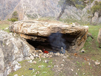
Afrosyb had wandered off to catch some supper in the turquoise blue lake, so we kicked back by the fire in the cave and the snow began to fall outside. Towards the end of the afternoon the sky cleared to reveal the dazzling white 5000m peak in front of the cave. A spectacular sunset followed...

Afrosyb had caught supper in a simple but highly effective way. He placed a net over a hole at the centre of a stone dam he had built across the stream and walked around the pond poking under stones with a stick and making noises. This is fishing as it's meant to be; it was very little effort and delivered the goods!
Freshly caught fish

At this point our fly-by-the-seat-of-our-pants approach began to unravel a little ... As night fell the temperature dropped like a stone. We both put on EVERYTHING we had and climbed into our borrowed (and not particularly warm) sleeping bags and proceeded to shiver our way through the night. To cap it all, the next day it emerged that our 'guide' had brought way too little food (i.e. bread) with him and furthermore deemed that the sugar he was carrying was his and not ours! (Sugary tea is always a good energy boost).
So we completed our climb to 3,800m on starvation rations, literally spinning out tiny chunks of Snickers as long as we could. Food REALLY tastes good when you actually need it... The view from the pass was spectacular (photos on the proper camera, sadly...), and we felt no small sense of achievement; we had climbed 2,000 vertical metres from the village.
Grr...

JM
Thursday, 7 June 2007
Uzbekistan - where the old is new and the new is old
If one country exemplifies the Silk Road it is Uzbekistan. Located between Persia and China the independent Khanates of Khiva, Bokhara and Samarkand thrived on the trade that passed through the barren deserts of Central Asia. These settlements stood alone in what was otherwise an area populated primarily by nomadic people.
Even after maritime commerce undermined the importance of the Silk Road the three cities made the headlines as recently as the 19th Century, as Britain and Russia eyed each other's empires suspiciously across expanse of Central Asia in what has been called 'The Great Game.' Russia sought aggrandisement and the primitive armies of the the Khanates proved no match for her modern armies. Britain, on the other hand, primarily sought defence of her interests in India, although some argued that a 'forward policy' in Central Asia was the best means to achieve this. Both sides sent ambitious young officers (all under 30!) into the region, often undercover on reconnaissance missions.
By the end of the Great Game both had broadly achieved their objectives: in ten years the Tsar had added an area half the size of the United States in Central Asia to his empire and Britain had successfully maintained a neutral buffer zone in Afghanistan and Tibet.
As I sat on the Transcaspian railway between Bokhara and Samarkand I read Curzon's account of its strategic importance as he travelled along it around 150 years before. He predicted that the railway would transform Central Asia from a curious wasteland into a fully mobilised frontier of the Russian empire. He was right: as we cruised along at a comfortable 110km it was hard to imagine the camel trains toiling through the desert, fighting off attacks from nomads so that they could sell their wares in the bazaars ahead.
But Soviet Russia tried hard to bring the old Silk Road cities to life. The old towns - in the case of Bokhara, shelled by the Red Army - have been painstakingly restored to their former glory. The old is brand new.
The results are spectacular. The Registan of Samarkand was for me undoubtedly the highlight, but the imposing walls of the desert town of Khiva and the mosques of Bokhara are also impressive.
Timur's Registan in Samarkand

The Ark in Bokhara

The walls of Khiva

But somehow the atmosphere is not there. Such is the extent of the Soviet restoration programme that, as a visitor, you feel you are rattling around in a vast infrastructure that rather dwarfs the fairly small number of tourists. It also lacks character. In part, this is because the line between museum and museum shop is non existent: local women are given free rein to set up shop inside the historic buildings, while they nominally check your ticket (for the twentieth time). The magnificent Coronation Rome in the Ark of Bokhara, for example, was almost completely masked with wall hangings for sale which were draped around it!
The other thing that was noticeable is that the sights are empty. This is of course inevitable, but is in sharp contrast to the spectacular - but living and breathing - mosques and shrines of the Middle East. Doubtless there are more tourists in high season, but we felt rather outnumbered by the caretakers / saleswomen, while the 'museum city' of Khiva was like a ghost town after the last day trippers had left.
I am sure that is overly simplistic to say that restoration 'ruins' these places - a charge that is often levelled at these cities: we saw photographs showing just how little would have remained with no restoration effort. Nevertheless, for me the feel of these places was no match for Palmyra in Syria, whose heyday was many centuries before these cities. Both Bokhara and Khiva felt a little too removed from the new towns; for this reason Samarkand was my favourite, with its stunning medressas (religious schools set around impressive quadrangles) and mausoleums of Timur and his relatives found scattered in the midst of the bustle of the bazaar of the new town.
Pilgrims pay their respects iShahr-i-Zindah (The Tomb of the Living King), Samarkand

In a museum we did find some fascinating old photographs of the fierce looking Khans in their massive wool hats, sitting in the very rooms we had just visited. These did the most to bring the Silk Road to life and so we bought a few copies to take away with us.
The extraordinary stories in Peter Hopkirk's book, The Great Game, also fired our imaginations to bring the cruelty of these once filthy slave towns to life. Most are too incredible to be fiction. In Bokhara, for example, we visited the 'bug pit,' a 25 foot hole into which prisoners were lowered and left to rot with all the wildlife that the desert could throw at them. One Great Game British officer, spent three years in it before being lead out to dig his own grave in the plaza outside the Ark, at which point he was beheaded. The reason? A volatile Emir (leader) of the city who was irritated by the Briton ignorance of Central Asian social etiquette at a time when he believed that Britain's disastrous foray into Afghanistan meant that it was not a power to be feared.
So the old is strangely new in Uzbekistan. In addition, the 'new' Uzbekistan sometimes felt more than a little tarnished; very little seems to have sprung up in recent times to replace the Soviet legacy. One small example that sticks in my mind is our hair-raising crossing of the creaking 'temporary' military bridge over the river Oxus, in our a tiny shared taxi crammed with four passengers and all their luggage. [It was the Russian equivalent of a Smart Car, which boasts a fuel efficiency every bit as amazing as its lack of comfort. As the man next to me turned Doctor Alban up to full blast on the stereo on his lap, the man in the front turned around proudly showed us a small bag with powder in it. "Narcotics, yes?" he grinned.]
Nukus, Karakalpakstan (North West Uzbekistan) - functional

We saw many other examples of the decaying Soviet legacy, but perhaps the most haunting image was our visit to the once thriving fishing port of Moynaq. Once on the Aral Sea, it is now a forlorn desert town more than 150km from the water, with rusty fishing boats decaying in the sand.
Formerly the Aral Sea shore, Moynaq

The reason for this is simple: the Soviet drive for cotton production led to a massive irrigation programme on the barren steppes on Turkmenistan and Uzbekistan. The Oxus (Amu Darya) and the Syr Darya rivers have been bled of water, resulting in a fall in the level of Aral Sea by 16m in 30 years. The water has become saltier and the climate drier - both are impacting the people as well as the wildlife of Uzbekistan.
Sadly, the solution is far from simple to execute. Although the situation could be reversed within 3 years if irrigation were to cease, there are now far too many mouths to feed that rely on the agricultural economy created in the last 50 years.
So Uzbekistan is a strange place to visit and not an easy place to love. The two Uzbeks we spoke to at some length were both bright, young people whose ambitions were set firmly outside of their country, perhaps in order to overcome the problems inside it.
Kuat, a teacher and a 'revolutionary' (i.e. a member of a young persons' democratic society) lamented the lack of civil liberties and what he believed was the government's deliberate policy to keep the autonomous northern region of Karakalpakstan (including the Aral Sea) in abject poverty, thus ensuring its reliance on subsidies from Tashkent. This in turn ensures that it it will not exercise its constitutional right to independence from the rest of Uzbekistan. He planned to leave the country and his family (again) in order to earn a meaningful wage - away from the endemic corruption of Uzbek officialdom.
Sabina, an incredibly erudite girl of 16 is already a successful businesswoman in Bokhara, selling handicrafts to tourists. She, along with her sister, provides for her widowed mother, despite the arrival of of a new stepfather on the scene. Clearly highly successful, she seemed upbeat about her future, but once again planned to leave her country and come to London to study in the near future.
For us, no Silk Road trip would have been complete without a visit to Uzbekistan. But while the brand new looking old cities were impressive, they were perhaps a little less evocative of the past than I had hoped. Meanwhile, for me, the newer Soviet legacy that survives in contemporary Uzbekistan feels rather tired and a little depressing.
JM
Subscribe to:
Posts (Atom)

